GEOTECHNICAL ENGINEERING1
IPSWICH
HomeGeophysicsElectrical resistivity / VES (Vertical Electrical Sounding)

Electrical Resistivity Surveys & VES for Ground Investigation in Ipswich

Sound ground. Sound decisions.

LEARN MORE

The shallow geology beneath Ipswich is dominated by the complex interfingering of glacial till, sands, and gravels left by the Anglian glaciation, overlying the Crag Group and, eventually, the Chalk bedrock. Mapping these transitions is not straightforward. A borehole gives you a point; a resistivity survey gives you the full transect, revealing where dense boulder clay gives way to water-bearing sand lenses that can surprise an excavation crew. Our vertical electrical sounding (VES) programmes cut investigation time by targeting the interfaces that matter: the top of rock, the base of made ground, or a suspected contaminant plume migrating through the Orwell terrace gravels. In a town where river terraces meet glacial deposits, guessing the stratigraphy is a budget risk few projects can absorb.

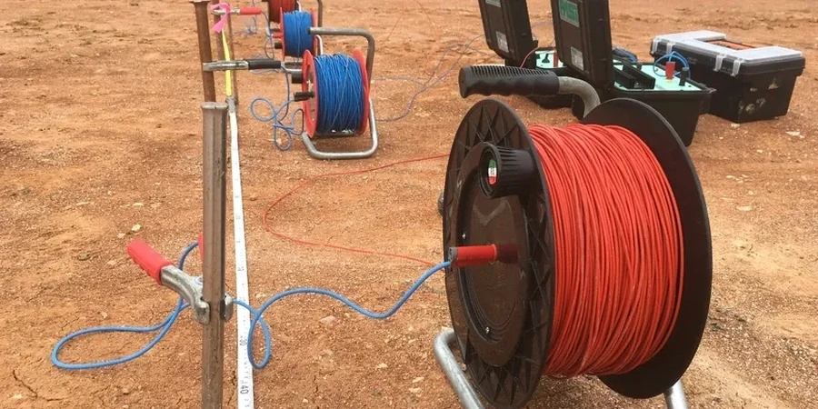
Resistivity profiling in Ipswich's glacial terrain exposes the hidden sand channels and clay lenses that boreholes alone often miss.
Our service areas

Process and scope

BS 5930:2015+A1:2020 and the relevant sections of Eurocode 7 (BS EN 1997-2:2007) frame every survey we run in East Anglia. The layered geology of Ipswich—with its stark resistivity contrast between saturated Crag sands and the overlying chalky till—makes electrical methods particularly diagnostic. We configure Schlumberger and Wenner arrays depending on whether the target is depth resolution or lateral continuity, and we tie each sounding to existing borehole control whenever possible. For sites near the Orwell estuary, where saline intrusion pushes resistivity values below 10 Ω·m, we adjust acquisition parameters to maintain resolution in the shallow section. The data integrates seamlessly with intrusive methods like spt drilling, giving you a ground model that is calibrated, not conjectural. Every final section includes a resistivity pseudosection with lithological interpretation and commentary on data quality, not just a colour plot.
Electrical Resistivity Surveys & VES for Ground Investigation in Ipswich
Technical reference — Ipswich

Local considerations

In Ipswich, we repeatedly see a specific failure mode on brownfield sites: old cellars and culverted watercourses, backfilled with uncontrolled material, that read as 'natural' on a sparse borehole grid. A resistivity line across the site picks up the linear low-resistivity anomaly immediately—the backfill is often wetter and more conductive than the surrounding till. Missing these features leads to differential settlement, unexpected dewatering costs, or, in the worst case, a collapse during piling. Another risk is misidentifying the top of the Chalk. The weathered putty chalk zone can be indistinguishable from overlying clays on a driller's log, but the resistivity jump at the fresh rock interface is unambiguous. Without that geophysical constraint, you either over-design the foundation depth or stop short and hit soft ground. The cost of a VES line is trivial compared to redesigning a foundation after excavation.

Need a geotechnical assessment?

Reply within 24h.

Email: contact@geotechnical-engineering1.com

Video resource

Reference standards

BS 5930:2015+A1:2020 – Code of practice for ground investigations, BS EN 1997-2:2007 – Eurocode 7: Geotechnical design – Ground investigation and testing, BS 7022:1988 – Guide for geophysical logging of boreholes for hydrogeological purposes, BS 10175:2011+A2:2017 – Investigation of potentially contaminated sites – Code of practice

Reference parameters

ParameterTypical value
Array configurationsSchlumberger, Wenner, dipole-dipole
Typical investigation depth (VES)Up to 60 m depending on spread
Data acquisition systemMulti-electrode resistivity meter with automatic stacking
Target resolutionLayer thickness >10% of depth
Reporting standardBS 5930:2015+A1:2020, BS EN 1997-2:2007
Typical deliverables1D VES curves, 2D resistivity pseudosections, interpreted geoelectric cross-sections

Frequently asked questions

How much does a resistivity survey cost for a typical Ipswich residential plot?

For a single-building plot requiring a VES sounding and a short 2D profile, budgets typically fall between £550 and £830. The final figure depends on access conditions, the required depth of investigation, and whether the survey needs to be combined with intrusive calibration points.

Can you survey a site with buried services and reinforced concrete?

Yes, but it requires careful planning. Buried metallic services and reinforced slabs introduce strong electrical noise. We always conduct a utility sweep before laying out arrays and will offset lines to avoid known infrastructure. The report notes any zones where cultural interference may degrade data quality.

How deep can electrical resistivity methods see in Ipswich's geology?

With a standard VES spread we routinely resolve layers down to 50-60 metres. The practical limit depends on the resistivity contrast between units—the contact between the Crag sands and the underlying Chalk is usually a strong, mappable reflector within that depth range. Deeper targets require longer spreads and more power.

What is the difference between VES and ERT, and which one do I need?

VES gives you a one-dimensional resistivity profile directly beneath a single point—it is fast and economical for mapping flat-lying layers. ERT produces a two-dimensional cross-section along a line, which is better for detecting lateral changes like channel edges, contaminant plume boundaries, or fracture zones. We recommend ERT for linear infrastructure and VES for foundation-level characterisation.

Location and service area

We serve projects in Ipswich and surrounding areas.

View larger map